


Before & After: ISRO Satellite Images Expose Scale Of Dharali's Flash Flood Catastrophe
Devastating flash floods hit Uttarkashi's Dharali & Harsil on Aug 5. ISRO satellite images revealed widespread destruction, aiding relief efforts amid ongoing rain threats.
Trending Photos

 5
5- 11
- 10
- 9
)
)
)
)
 "Before & After: ISRO Satellite Images Expose Scale Of Dharali's Flash Flood Catastrophe") ISRO Satellites Expose Scale Of Dharali's Flash Flood Catastrophe (PHOTO: X/@isro)
ISRO Satellites Expose Scale Of Dharali's Flash Flood Catastrophe (PHOTO: X/@isro)The catastrophic flash floods, which hit the Uttarkashi district of Uttarakhand on August 5, have left a record of havoc in the villages of Dharali and Harsil. Heavy rainfall caused a deluge of water, mud, and rocks, which swept everything away, including houses, buildings, bridges, and roads, killing several people and cutting off entire populations.
And now, satellite images from the National Remote Sensing Centre (NRSC) and the Indian Space Research Organisation (ISRO) have given a stark visual estimate of the destruction, bringing out the sheer magnitude of the disaster.
Satellite Reveals Extent Of Devastation
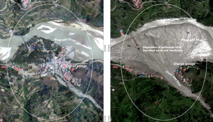
With high-resolution imagery from India's Cartosat-2S satellite, NRSC and ISRO compared post-disaster images of August 7, with pre-disaster images of June 13, 2024. The results are stark:
Flash Flood Scars: Satellite imagery clearly indicated broadened river courses, changed river morphology, and widespread destruction of human habitation and structures.
Huge Debris In Dharali: In the meeting point of the Kheeri Gad and Bhagirathi River, around 20 hectares (750m x 450m) of Dharali village are now blanketed by a fan-shaped deposit of debris and mud.
General Destruction Of Buildings: Many buildings have been totally destroyed or buried underneath mudflow. Most of the houses of Dharali are buried under mounds of debris and mud, making them habitable.
This. critical satellite data is already proving extremely useful for continued relief and rescue efforts, enabling teams to find stranded people and where road connectivity has to be re-established.
Satellite Insights Aiding Rescue & Relief Ops
ISRO/NRSC used Cartosat-2S data to assess the devastating Aug 5 flash flood in Dharali & Harsil, Uttarakhand.
High-res imagery reveals submerged buildings, debris spread (~20ha), & altered river paths, vital for rescue teams on… pic.twitter.com/ZK0u50NnYF — ISRO (@isro) August 7, 2025
Himalayas' Increasing Vulnerability
The Uttarkashi tragedy highlighted the increasing susceptibility of Himalayan settlements. Researchers are currently working to identify the specific reasons behind this flood, looking into whether the event was sparked by extreme rains, melting glaciers, or geo-structural tectonic movement. Climate change and reckless human intervention are also believed to be major causative agents of the growing frequency and severity of similar disasters in the vulnerable Himalayan landscape.
Relief Operations And Preparedness In The Future
Data obtained from the satellite images is influencing Indian Army and relief groups to search for missing individuals and re-establish vital road connections. Still, the disaster itself serves as a harsh reminder of exercising utmost care while dealing with ecologically delicate areas like the Himalayas. The stoppage of indiscriminate construction and felling of trees is considered imperative to avert such future tragedies.
New Rain Menaces Relief Work
As on Friday, August 8, 10:38 AM IST, recent satellite images (INSAT-3DR + Bhuvan Map) show moderate to heavy rain activity over Uttarkashi and the surrounding area. The image signifies:
Red-colored regions: Point to a probability of moderate to heavy rain in areas such as Dehradun, Chakrata, Mussoorie, Kedarnath, Gangotri, and Tehri.
Yellow marker: Locates Uttarkashi, indicating continued rain activity in the vicinity of the immediate disaster area.
Although the weather in Uttarkashi and the surrounding regions had improved slightly yesterday, August 7, with relief work advancing, today's fresh projection of heavy to moderate rain presents a serious challenge. Such rain may result in more mud and debris on roads, making it difficult for rescue and relief workers to approach stranded persons. Helicopter sorties may also be disrupted because of the low visibility created by clouds and rain. Relief teams are thus encouraged to be very careful and organize their operations dynamically according to the actual weather conditions.
Stay informed on all the latest news, real-time breaking news updates, and follow all the important headlines in india news andworld News on Zee News.

Live Tv
 "Will Hindus get justice in Bengal's Murshidabad?")
 "DNA: Uproar over freebies in Delhi!")
 "DNA: AIMIM plans to field 2020 Delhi riots accused Shahrukh Pathan")
 "DNA: A report showing the reality of Bangladesh")
 "DNA: Power Theft Allegations Against SP MP Ziaur Rahman Barq")
 "DNA: Hot Tea Linked to Cancer Risk!")
 "DNA: Why Jordan Fears After Syria’s Coup?")
 "DNA: NSA Ajit Doval’s China Visit - Inside Story")
 "DNA: Gandhi Family Ruined My Career, says Mani Shankar Aiyar")
 "DNA: Ground Report- Tight Security Arrangements for Mahakumbh")
